This last year we haven’t been traveling as much (thanks, economy and job market!), but we have been exploring Colorado a lot more! We feel so fortunate to live in such a great state with all of its outdoor recreation.
There are many amazing hikes within an hours’ drive for us and so we made the most of our free time this year by exploring those trails. From checking out the golden aspens to setting our sights on glaciers, we saw a lot of Colorado’s natural beauty this year.
Since we ended up doing a lot of hiking this past summer and fall, we thought it would be fun to round up our favorite hikes of 2025.
The best hikes we did in Colorado this year
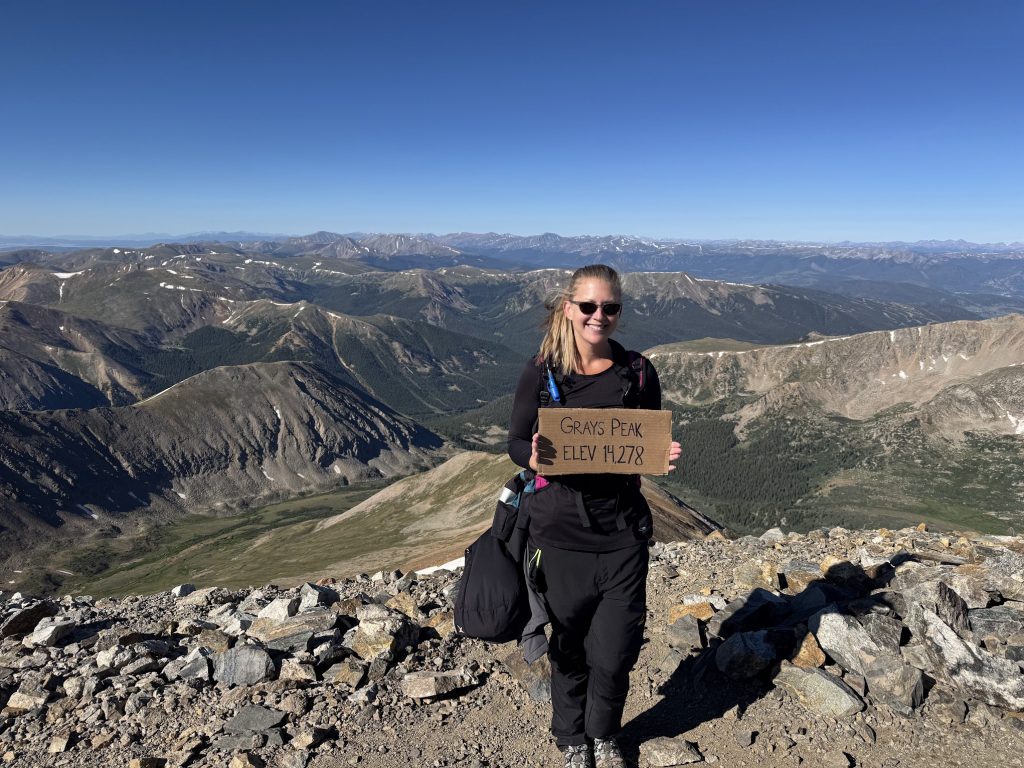
Grays and Torreys
- Location: Silver Plume, CO
- Route type: Out and back
- Distance: 8.25 miles
- Elevation gain: 3,600 ft. (Start at 11,280 and summit at 14,278)
- Difficulty: Class 1 14er/Difficult
- Bathrooms at trailhead: Yes
So, I actually did this hike with some of my best friends from back home and it was such a gorgeous hike. Grays and Torreys are my second and third fourteeners that I’ve done since living in Colorado since 2010. I know, I’m a bad Coloradan.
But these views and experience was well worth the trip!
Prepare for an early start for these 14ers! We hit the trail at 5:10 a.m. And we were not alone with that early start time. It was gorgeous watching the sun come up and turn the mountains golden as the day began.
We got to the summit of Grays at 8:50 a.m. We then cut down and across the connector trail and got to the summit of Torreys at 10:40 a.m. We stayed at the top and had some snacks and chugged plenty of water. We then made our way back down, and we got back to the parking lot at 2:15 p.m. Talk about a long day!
This hike can be challenging, especially if you’re not used to the altitude. It is stunning as the views are epic at the top, but do prepare for colder temperatures and a lot of wind at the summit. And put on sunscreen as you are higher up.
Do keep in mind that altitude sickness is very real and can impact anyone. Even I was starting to feel some of its effects as we were coming back down and I’ve lived here for 15 years. Bring plenty of water, sports drinks, snacks, and take your time.
Warning! The road to the trailhead is rough. Make sure you’re in a 4WD vehicle with good clearance. The road is not maintained. We were bouncing around like Jim Carrey in Ace Ventura 2 when driving up and down it in our SUV.
And fair warning, there are not a lot of spaces to park up at the top. We parked at 4:30 a.m. and got one of the last spots in the lot. Yes, our alarms went off at 2:30 a.m. It is a long day, but worth it to cross two 14ers off the bucket list in one go.

Crater Lake at Maroon Bells
- Location: Aspen, CO
- Route type: Out and back
- Distance: 3.45 miles
- Elevation gain: 692 ft.
- Difficulty: Moderate
- Bathrooms at trailhead: Yes
While I’ve done a few 14ers, I’m not skilled enough to attempt climbing the Maroon Bells. They are dangerous climbs that require technical knowledge and skills I simply do not possess. Fortunately, when we went to check out the Maroon Bells, there is a great hike that we could definitely do!
We opted to do Crater Lake when we visited the Maroon Bells and it was a fantastic hike. It does get steep in some areas and is pretty rocky in others, but it does cover some beautiful terrain.
You wander though aspen groves, open areas, and then end up at the lake with expansive views and a front-row seat to the bells.
We opted to take the shuttle to Maroon Bells and parked at the Aspen Highlands Center.
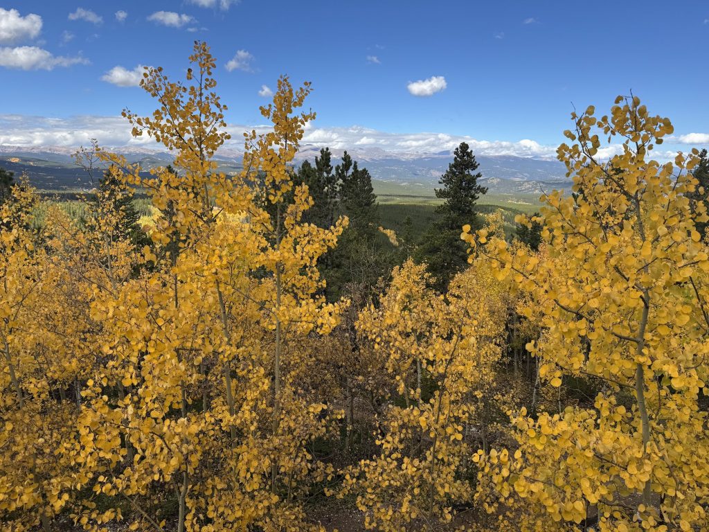
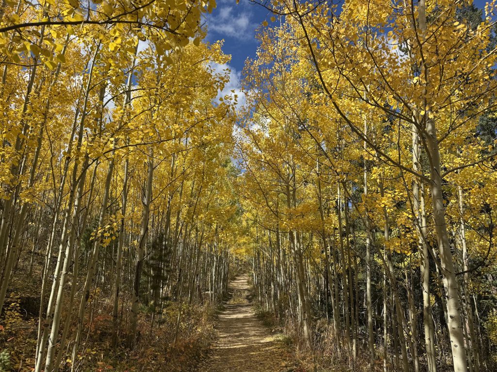
Racoon Trail
- Location: Golden Gate Canyon State Park (Golden, CO)
- Route type: Loop
- Distance: 3.5 miles
- Elevation gain: 514 ft.
- Difficulty: Moderate
- Bathrooms at trailhead: Yes
This trail (yes, it’s actually Racoon not Raccoon) kept popping up in my Instagram feed as an amazing option to see the golden aspens and in late September, it did not disappoint!
This was absolutely breathtaking as you weave through aspen groves and then get views of the surrounding mountain ranges popping with colorful pockets of groves. It felt like a fairytale or movie as the colors were so stunning.
The hike does have some steep areas and some rocky bits, but otherwise is a relatively easy trail with some flat sections. I parked at the Reverends Ridge campground and went up to Panorama Point, and then looped back around again.
This is a gorgeous fall hike and one I hope we can do again next year when the aspens are at their peak.
Do note that you have to pay for parking ($12) or if you have a Colorado State Parks pass it’s free to park.
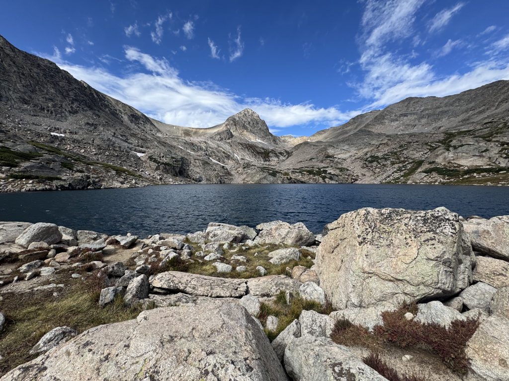
Blue Lake
- Location: Brainard Lake Recreation Area (Ward, CO)
- Route type: Loop
- Distance: 8.4 miles
- Elevation gain: 994 ft.
- Difficulty: Moderate
- Bathrooms at trailhead: Yes
We technically did Blue Lake via Mitchell Lake (as we did not check our parking location before booking, oops!). But it worked in our favor as we got more hiking in and got two see two incredible lakes instead of just one.
Blue Lake is a glacier trail and while a bit chilly with the wind coming off the lake, it was a stunning hike. We had a variety of terrain with rocky sections, meandering through forest settings, and then hitting the glacier. This is a great option if you want a Rocky Mountain National Park experience without actually going to the park and battling it out with the crowds.
We did have to make a reservation for parking and pay for it ahead of time, which is why we ended up at a different lot, but it all worked out.
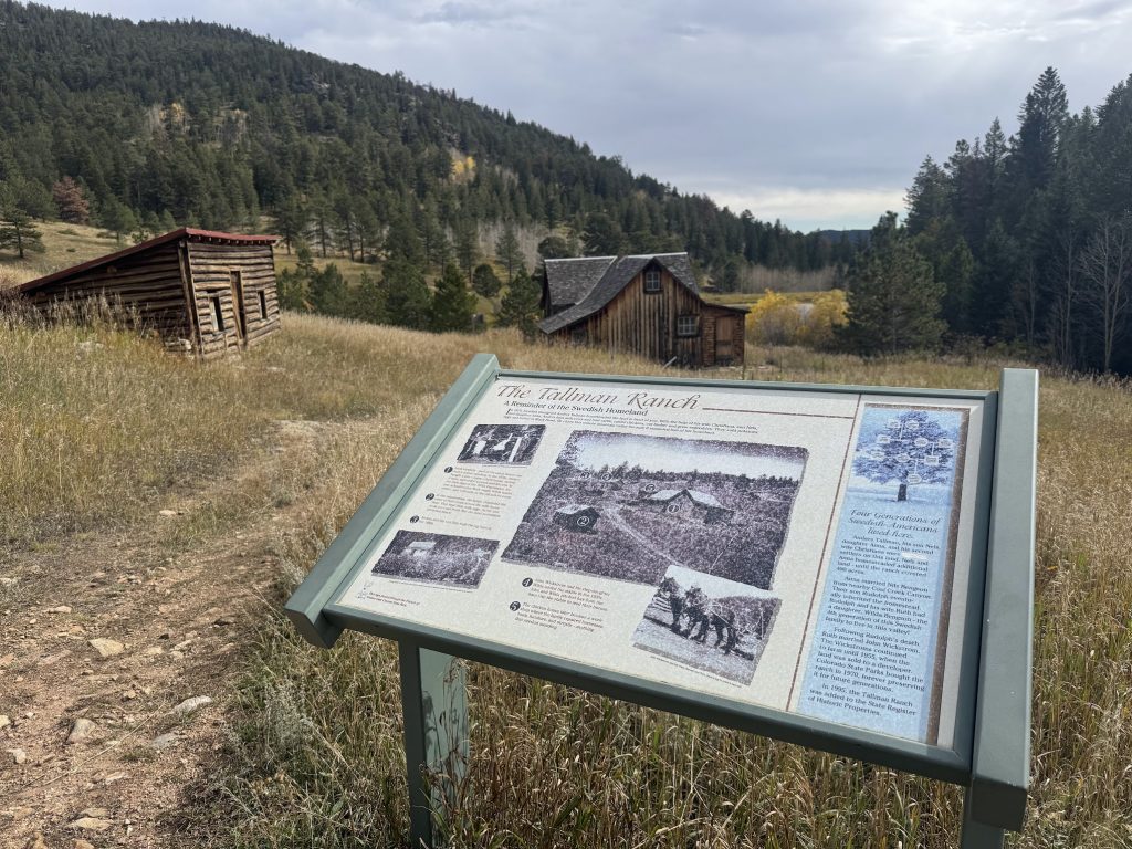
Snowshoe Hare + Forgotten Valley
- Location: Golden Gate Canyon State Park (Golden, CO)
- Route type: Loop
- Distance: 3 miles (6 miles if adding on Forgotten Valley)
- Elevation gain: 756 ft.
- Difficulty: Moderate
- Bathrooms at trailhead: No, but nearby within a five-minute walk
I really enjoyed the other hike in Golden Gate Canyon State Park and opted to check out other trails and decided to go on the Snowshoe Hare loop, especially since it starts near a place called Dude’s Fishing Hole. If that’s not Colorado, I don’t know what is.
This hike is definitely more green than Racoon Trail. There are some aspens, but it’s more wooded and a lot more rocky. It’s a great, challenging hike, but don’t expect the same amount of color as some other trails.
Since it was only 3 miles, I opted to continue onto the Buffalo Trail and head toward Forgotten Valley, about a 1.5-mile add-on. It was a great idea as it led me to Tallman Ranch, a preserved historical site from 1876. The trail to the ranch isn’t the most exciting, but the abandoned buildings are pretty cool to see.
This trail is in the same state park as Racoon Trail so you need to pay for parking or have a Colorado State Parks pass. I just pay for mine with my vehicle registration and they just check my license plate.
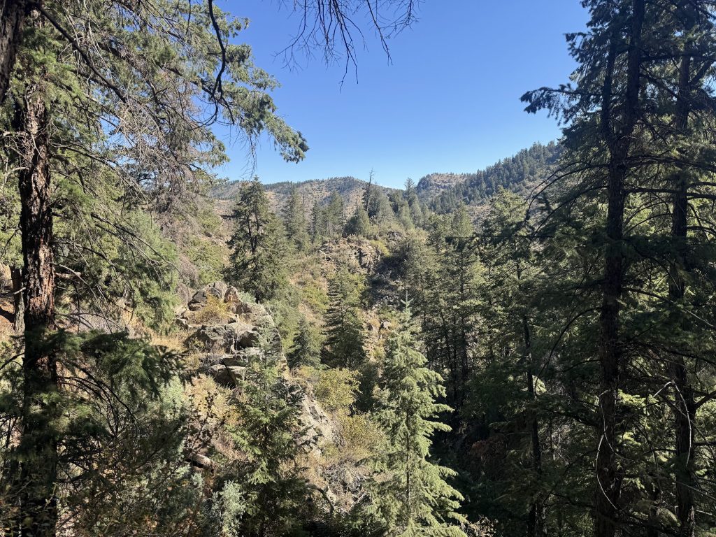
Beaver Brook/Chavez Trail
- Location: Genesse Park (Evergreen, CO)
- Route type: Loop
- Distance: 5.1 miles
- Elevation gain: 1,100 ft.
- Difficulty: Moderate
- Bathrooms at trailhead: Yes
If you want to head toward the mountains but aren’t ready to commit to driving along I-70 from Denver for too far, this could be a great hike. It’s just outside of Evergreen, so you have great views but it’s also an easy drive.
The hike takes you through wooded areas and there are a lot of streams and little waterfalls to see along the way. Plus, there are some aspen groves, which means this could be stunning in mid- to late September as they change colors.
So this hike was beautiful and easy enough, though I will say I actually got hurt pretty bad on it. Somehow I tripped on the trail given the loose dirt situation and messed up my knee pretty bad. We did this hike in August and I still feel some residual pain in my knee and I lost like three layers of skin, my kneecap is practically glowing because it’s so new and pale still. User error, for sure, but fair warning, watch your step!
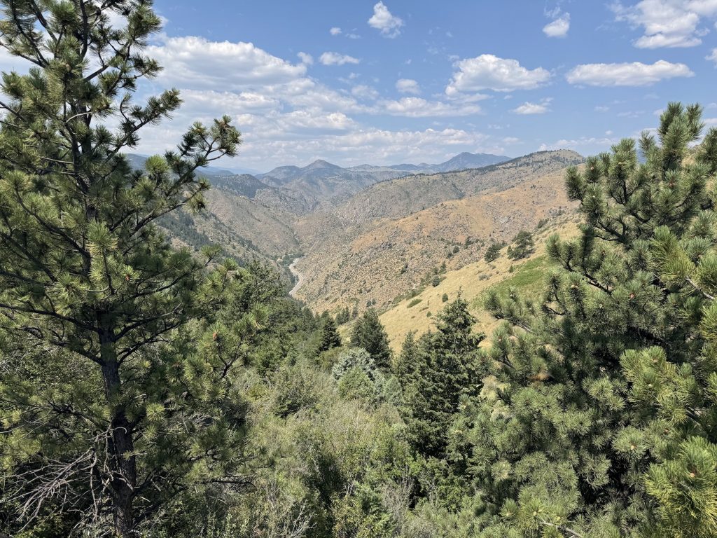
Lookout Mountain
- Location: Windy Saddle Park (Golden, CO)
- Route type: Out and back
- Distance: 3 miles
- Elevation gain: 521 ft.
- Difficulty: Moderate
- Bathrooms at trailhead: Yes
This was another trail I did with my friends when they were in Colorado and we used it as a warm-up to hiking Grays and Torreys. This was a fun trail just outside of Golden that leads you to the Buffalo Bill museum, should you want to check it out.
The views of Golden and the surrounding areas are great and this trail wasn’t too crowded when we went. It’s also a pretty easy-to-moderate trail, though plan for not much tree cover on this hike. You do wind through some tree-heavy areas but this hike is generally pretty exposed.
Here’s hoping we can plan a few more amazing hikes or revisit some of these fantastic trails in 2026!